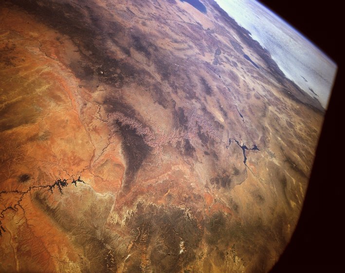
Снято миссией Space Shuttle #40, рулон 151, кадр 14,
при прохождении 34.5 сев. широты и 113 зап. долготы.
Дата: 7 июня 1991, время: 16:42:07 UTC. Высота 154NM = 258км.
...Да, чуть не забыл: 35-й виток орбиты :) .
Вот что по этому поводу пишет автор (NASA that is):
STS040-151-014 The Grand Canyon of the Colorado River, Arizona, Utah, Nevada, and California, U.S.A.
June 1991 The Grand Canyon can be seen near the center of this southwest-looking, high-oblique photograph.
This panoramic view of the southwestern United States shows the course of the Colorado River as it
traverses from Lake Powell in southern Utah, through the Grand Canyon, westward to Lake Mead in eastern
Nevada, and then southward to Mexico and the Gulf of California. The dark forested areas on either side
of the Grand Canyon are the Kaibab Plateau to the north and the Coconino Plateau to the south.
Snow-covered Humphreys Peak of the San Francisco Peaks is visible south of the Coconino Plateau.
Just south of the mountains is the tree-covered Mongollon Rim. The bright orangish-red sands of the
Painted Desert can be seen east of the Grand Canyon. The forested Wasatch Mountain Range of southern
Utah is visible north of the Kaibab Plateau. Southwest of Lake Mead, the Salton Sea and the Imperial
Valley of southern California can be seen. West of the Salton Sea, clouds cover the Pacific Ocean.
Один интересный вещь, не упомянутый NASA: видите черную трехконечную кляксу на западной (на фото -- правой) оконечности Каньона? А теперь найдите серое пятнышко с более светлыми краями. Маленькое такое, можно накрыть одним мышиным курсором. Это -- Las Vegas. Для масштаба.
Для любителей -- здесь лежит Hi-Resolution версия того же кадра (317Kb, JPEG).
Только для фанатов! предлагается Mega-Resolution версия (4Mb, JPEG -- ДА, 4 МЕГА _ЖАТЫЙ_!) (с НАСАвского сайта -- я у себя такое держать не подписывался). Ох и употел же я в попытках ее открыть! Теперь мечта идиота -- напечатать это где-нибудь, желательно -- на глянцевой и как минимум А1 бумаге.
Видите пару клочков облаков с тенями -- в верхней части? Игрушка, правда?
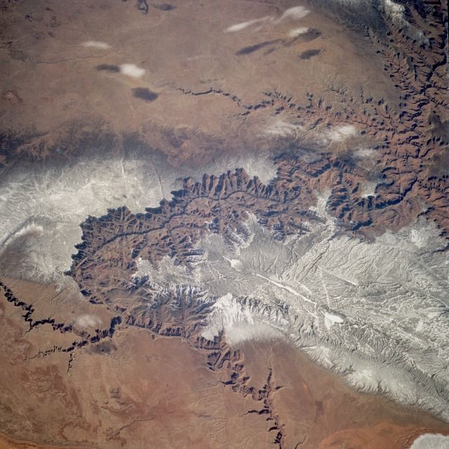
И опять слово -- автору:
STS060-083-005 Grand Canyon, Arizona, U.S.A. February 1994 The Grand Canyon, one of the deepest canyons in the world with a depth of 1 mile (1.6 kilometers), can be seen in this spectacular, west-looking, low-oblique photograph. The Colorado River cut through rocks billions of years old to create this canyon. The Grand Canyon is 277 miles (466 kilometers) long and averages nearly 10 miles (16 kilometers) in width. The snow-covered, forested Kaibab Plateau (north of the canyon) and the Coconino Plateau (south of the canyon) are visible. The western portions of the Painted Desert can be seen east of the canyon where the Little Colorado River joins the Colorado River.
Эти и множество других замечательных снимков Земли (и не только) из космоса (и не только) принадлежат NASA. Особенно рекомендую совершенно восхитительный архив фотографий Земли -- все миссии NASA с 1968 года! Там же -- шесть(!) поисковых машин, хороших и разных. От простой и наглядной "Тыкни в карту" до волнующе-подробной Technical Search -- сюда просто рекомендую заглянуть всем тем, кому небезразличен (1) космос и "как это делается" или (2) IT и "как это ищется".